


Malta Garmin topographic map
$22
Malta topo map for Garmin
Navigate Malta’s compact island landscapes, historic cities, coastal roads, harbors, beaches, and walking routes with detailed Garmin maps designed for offline use. This Garmin GPS map covers Valletta, Sliema, St. Julian’s, Mdina, Rabat, Gozo, Comino, ferry connections, coastal villages, and rural interior roads.
Designed as an OSM map tourist Garmin product, the map is useful for city sightseeing, scooter travel, rental-car routes, coastal walking, cycling, and island exploration. These outdoor maps Garmin travelers use include streets, footpaths, coastlines, ferry terminals, viewpoints, beaches, archaeological sites, and tourist services.
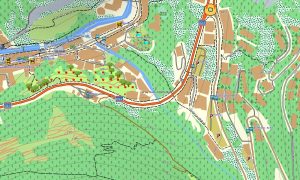
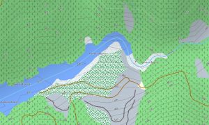
This Garmin GPS map functions as an OSM topo map with elevation contours, cliffs, valleys, coastal terrain, rural tracks, harbors, and settlement information. The Garmin map helps visitors navigate dense urban areas, narrow village streets, rugged coast paths, and Gozo’s countryside.
Built from open street maps Garmin compatible data, the product delivers strong local detail for a small island nation with complex road layouts. Users can download Garmin map files instantly, and updated Garmin OSM maps help maintain accurate roads, paths, and points of interest.
Maps for Garmin navigator devices assist with driving, scooter routes, ferry approaches, and navigation between beaches, temples, towns, and viewpoints. A map for Garmin watch supports walkers, runners, hikers, and cyclists exploring urban promenades or coastal paths.
Key Features:
- Topographic maps for Garmin covering Malta include roads, footpaths, tracks, ferry links, coastlines, harbors, beaches, villages, towns, and elevation contours
- Natural features include Mediterranean cliffs, limestone plateaus, coastal bays, beaches, valleys, rocky headlands, sea caves, islands, and dry landscapes
- Road coverage includes urban streets, village lanes, coastal roads, rural tracks, ferry terminal access, harbor roads, bridges, and tourist routes
- Points of interest include temples, fortifications, old towns, churches, museums, beaches, viewpoints, marinas, lighthouses, ferry ports, and archaeological sites
- Routing support allows compatible maps for Garmin navigator devices to guide island driving, city navigation, scooter routes, and ferry-connected travel
- Full compatibility supports handheld Garmin GPS units, automotive devices, outdoor navigators, and selected devices using a map for Garmin watch with OSM topographic maps
Only logged in customers who have purchased this product may leave a review.

Reviews
There are no reviews yet.