


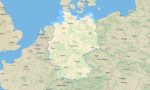


Germany Garmin topographic map
$36
Germany topo map for Garmin
Navigate Germany’s efficient road network, historic cities, forests, rivers, alpine areas, and cycling routes with accurate Garmin maps for offline use. This Garmin GPS map covers Berlin, Munich, Hamburg, Cologne, Frankfurt, the Black Forest, Bavaria, the Rhine Valley, the North Sea coast, and the Baltic region.
Developed as a complete OSM map tourist Garmin solution, the map supports road travel, hiking, bicycle touring, business trips, campervan routes, and city exploration. These outdoor maps Garmin users appreciate include detailed streets, trails, waterways, parks, forests, mountain paths, and tourist facilities.
This Garmin GPS map serves as an OSM topo map with contour lines, hills, valleys, rivers, reservoirs, woodland tracks, and settlement layers. The Garmin map helps users plan routes through the Bavarian Alps, Harz Mountains, Saxon Switzerland, Eifel, and other regions where topographic detail improves navigation.
Created from open street maps Garmin compatible sources, the product delivers strong urban and rural accuracy. Users can download Garmin map files instantly and install them on compatible Garmin devices. Regular Garmin OSM maps updates help keep road changes, trail information, and points of interest current.
Maps for Garmin navigator devices are useful for autobahn travel, city navigation, rural journeys, cycling routes, and access to national parks. A map for Garmin watch supports running, hiking, cycling, and outdoor fitness throughout Germany.
Key Features:
- Topographic maps for Garmin covering Germany include roads, cycleways, tracks, hiking trails, rivers, lakes, forests, settlements, parks, and elevation contours
- Natural features include the Bavarian Alps, Black Forest, Rhine Valley, Harz Mountains, Baltic coast, North Sea wetlands, lakes, river basins, and sandstone formations
- Road coverage includes autobahns, federal roads, regional roads, city streets, rural lanes, forest roads, tunnels, bridges, and cross-border connections
- Points of interest include castles, old towns, museums, cathedrals, ski areas, viewpoints, campsites, railway stations, monuments, breweries, and national parks
- Routing support helps compatible maps for Garmin navigator devices provide efficient guidance across urban networks, rural roads, and long-distance routes
- Full compatibility supports handheld Garmin GPS units, automotive navigators, cycling devices, and selected models using a map for Garmin watch with OSM topographic maps
Only logged in customers who have purchased this product may leave a review.


Reviews
There are no reviews yet.